

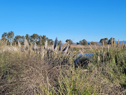
Palo Alto has a long and distinguished history of identifying, protecting, and maintaining open space. The generosity and dedication of nature-loving residents over many decades has led to a park and open space system without equal among cities this size. Places like Foothills Park and the Baylands Nature Preserve are treasures that we enjoy and that many animals find a home in.
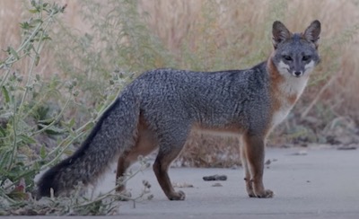
A gray fox in Palo Alto’s Baylands Nature Preserve. Source: Urban Wildlife Research Project
But our fight for open space cannot rest on its laurels as pressure to develop grows stronger and land grows scarcer. In this blog post, I review three recent cases that reflect some of these tensions, with different levels and types of tradeoffs. My goal is to illustrate some of the conflicts we face in trying to sustain biodiversity by providing varied and valuable habitats for wildlife.
Transitional Housing at the Baylands
The site selected for Project Homekey, a much-needed 88-room transitional housing project at the end of San Antonio Road, is a low-lying lot of 1-2 acres adjacent to office buildings and a former water treatment plant.
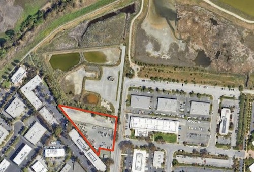
The site chosen for Project Homekey at 1237 San Antonio Road is shown in red, with San Antonio Road along the right border.
Most of the site is zoned as “Major Institution / Special Facility”, which is appropriate for such a development. But a small quarter-acre portion of the end of the site is zoned as Public Conservation Land and abuts the same.
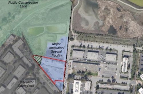
The end of the site is zoned as “Public Conservation Land”. Source: Palo Alto City Council staff report, 2022
This portion of the site has not in fact been conserved, and looks and functions like the rest of the property.
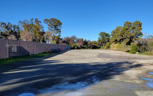
The quarter-acre of public conservation zoned land is the end portion of this gravel lot.
The staff report to City Council recommending that the zoning of this portion be altered to accommodate the new housing development writes that “The requested change to the designation would bring this segment of the site into alignment with the adjoining portions and align with the existing and proposed future use”, and members of both the Planning and Transportation Commission and the City Council saw no reason to disagree.
Looking towards the Public Conservation Land from the end of the Project Homekey lot
I support this zoning change. The use of a very small piece of land has an outsized impact. Given its adjacency to conservation land, it will be important to minimize light and noise pollution. I also recommend that we compensate for this zoning change by doing more restoration work on the adjacent old Los Altos Water treatment plant, at least the portion zoned “Public Conservation”. When you have conservation land, if you don’t use it as such, you risk losing it. “Love it or lose it”. And that brings me to the next case.
Waste Processing Infrastructure in Byxbee Park
In 2011 Palo Altans voted (65%) to set aside ten acres of Byxbee Park adjacent to the city’s water treatment plant for a facility that would process our yard waste, food scraps, and sewage sludge efficiently and in an environmentally friendly way. If, after ten years, no such facility were built, then the city could revert it back to parkland.
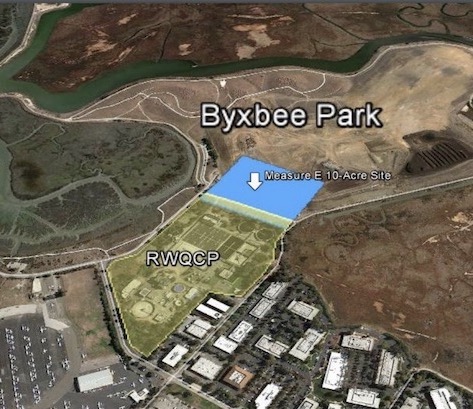
Measure E set aside ten acres of Byxbee Park (shown in blue) for ten years to explore a facility that could process all of our organic waste. (Source: Palo Alto Parks and Recreation Commission staff report, 2022)
After several years of investigating potential solutions, the city concluded in 2017 that the options for a new facility to process all three streams of organic waste, as stipulated by the measure, were too expensive. We instead opted to send our yard waste and food scraps to San Jose, and to dewater our sewage on site and send the solids to Merced and Fairfield, where they are processed and converted to compost and similar uses. These new procedures are much more environmentally friendly than our old ones (e.g., incinerating our sewage), and they use state-of-the-art equipment at the processing sites. The city has in addition decided to invest significantly in an improved water treatment facility so that our treated wastewater can be used more widely for irrigation and so it will not degrade the Bay.
So the question now, eleven years after the parkland was undedicated, is: Do we revert the ten acres to parkland, or do we continue to reserve it in the hope that more affordable technology will be available to process our waste in our own city? The Parks and Recreation Commission recently voted to recommend that City Council rededicate this site as parkland, reasoning that it has already been held in limbo for a decade and needs to be returned to its original purpose per contract with the voters. But others argued that the site is not pleasant for people and is very well placed for waste treatment, so should continue to be reserved for that purpose.
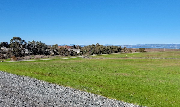
The ten acres of undedicated parkland adjacent to the water treatment plant, which can be seen in the back.
I believe that we should rededicate this space as parkland. Residents did not vote to set aside this property in perpetuity in the event that some development at some point might be found suitable. The vote was for a specific use for a specific time period. Our city has taken many practical, cost-effective steps to responsibly process our waste. It cannot be a priority to make yet another significant investment for an incremental improvement. Moreover, anything other than a facility to process all three streams of organic waste on this site would require a new vote anyway.
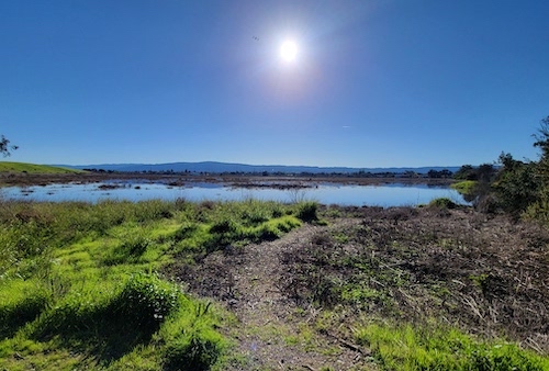
The Emily Renzel Wetlands lie just a few feet away from the parkland in question.
The area in dispute is a sizable chunk of Byxbee Park, with a well-used walking path and a variety of plants that benefit from access to the nearby treated water, which also serve the purpose of visually screening the water treatment plant. If we rededicate this area as parkland, we can better protect it, reduce the amount of disturbance on the site, and potentially get grants to further develop habitat. One idea I’ve heard is to daylight the pipe running under the site that conveys tidal overflow between the Harbor Marsh on one side and the Wetlands on the other. Returning this flow to the surface would add capacity and resilience to that overflow system as the Bay waters rise, provide continuity for the marsh, return more of the land to its natural state, and create a corridor for wildlife between the two areas. That may not happen for a while, but it’s an interesting idea. And speaking of wildlife corridors…
Private Home in Open Space
A third current example we are seeing where we can lose valuable open space is in the development of private lots. Palo Alto has a few residential areas zoned as “Open Space,” a designation that should prioritize the preservation of the natural environment on these lots. Some of these properties are located in a small area between Arastradero Preserve and Foothills Park. Two years ago a couple purchased an undeveloped 5.3 acre lot there, with a creek running the length of the property.
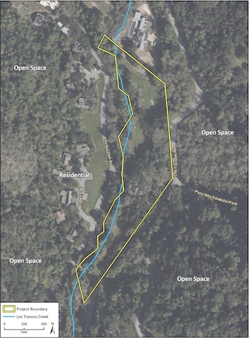
575 Los Trancos Woods is on the western edge of Palo Alto, adjacent to the Hawthorns Area of the Windy Hill Open Space Preserve. Los Trancos Creek runs the length of the rear of the property. Source: Palo Alto City Council staff report, 2023
They designed plans for a two-story 7245 sf home, a 895 sf accessory dwelling, a swimming pool, and other hardscape, nestled in a flat clearing at the rear of the lot, surrounded by mature oak trees, hovering close to the creek.
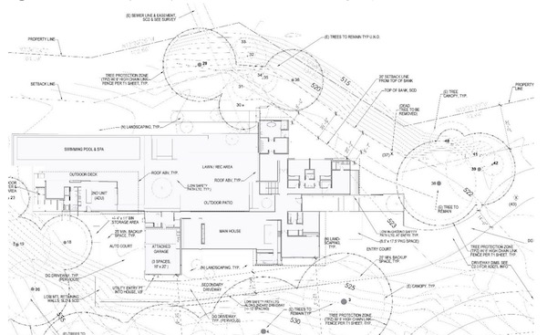
The plans show the two-story home close to and loosely paralleling the creek. Source: Palo Alto City Council staff report, 2023
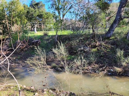
Stream corridors are particularly valuable for wildlife. Representatives from the Sierra Club and Audubon Society, writing about these plans, comment that “riparian communities in the Western states, such as California, provide habitat for up to 80 percent of western wildlife species.”
Palo Alto recognizes the value of riparian corridors and has special protections for Stream Corridor environments. However, we have neglected to update those guidelines based on best practices. Santa Clara County’s General Plan, and even Palo Alto’s own Comprehensive Plan, recommend a 150 foot buffer between a stream and nearby development. But our development guidelines as written require only 20 feet. This house, sited at the back of the property, touches and comes close to that minimum creek setback for much of its length, while affording a generous 88+ feet from the road in front (only 30 feet is required). The home is carefully screened from the street, but it hovers over the creek and the wildlife there.
Parts of the residence are sited just 20 feet from the stream bank, as shown by temporary “story poles” on the lot.
The Planning and Transportation Committee was concerned about the home’s proximity to the creek, and has asked that the house incorporate automatic blackout shades on the upper story windows facing the creek and interior and exterior sensors to ensure lights are off when not needed.
But is that enough? There will inevitably be noise, light, and other disturbances from the two-story residence and swimming pool so close to the creek. Palo Alto’s setbacks do not adequately protect this wildlife corridor, and the critical riparian ecosystem will be significantly degraded. While it would certainly be possible to move the house back some, it’s not clear what Palo Alto can enforce.
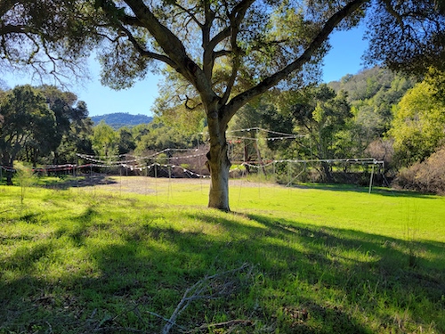
Architects have placed the structure almost 90 feet back from Los Trancos Road.
Palo Alto should revisit its Stream Corridor protections and ensure that they reflect best practices. In the case of this property, I hope that the City can offer the owners some options that would make it easier for them to shift the house back, perhaps to match the neighbor’s setback of 55 feet. (1) If you have suggestions, you can submit comments to City Council prior to Monday evening’s discussion.
In reading the zoning guidelines and listening to debates on this and the Measure E topic, I was struck by how we so naturally consider our own vistas and experiences when siting and designing buildings and spaces, but just as easily may neglect the wildlife perspective -- their vistas and their experiences. Yet wildlife is more threatened now than ever as development etches away at habitat. This is where biologist expertise and local policies matter. We should be giving wildlife an assist, not adding yet more stress, if we want them to stick around here and even thrive. It is not easy with so many counter-pressures. Pushing back will take continued attention and advocacy from concerned Palo Altans.
Notes and References
1. It is ironic that Fire Department code requires the owners to maintain vegetation within 30 feet of the home, which would mean regular incursion into the stream corridor. That seems inconsistent with protections that require that “All native riparian vegetation within 100 feet from the top of bank shall be retained.”
Current Climate Data (December 2022)
Global impacts, US impacts, CO2 metric, Climate dashboard
Interesting fact about the potential speed of EV adoption: “A decade ago, electric cars represented less than 3% of all car sales in Norway. Now they’re over 80%.” Source: Elektrek
Comment Guidelines
I hope that your contributions will be an important part of this blog. To keep the discussion productive, please adhere to these guidelines or your comment may be edited or removed.
- Avoid disrespectful, disparaging, snide, angry, or ad hominem comments.
- Stay fact-based and refer to reputable sources.
- Stay on topic.
- In general, maintain this as a welcoming space for all readers.